Geognostics has acquired the IP assets of Frogtech Geoscience - including SEEBASE™ services, multi-client products, plate reconstruction model, global terranes database and other proprietary R&D.
Geognostics will continue to develop and support SEEBASE™ services as part of our company delivery.

SEEBASE™ Multi-Client Studies available for license:
Gulf of Mexico
Guyana – Suriname
Brazil Atlantic Margin
Offshore Argentina
Northwest Africa Margin
Mid-North Sea High
Rockall Trough
Equatorial Africa Margin
Southwest Africa Margin
Onshore North Africa
North Atlantic
Barents Sea
Black Sea
Caspian Sea
Myanmar
South China Sea
Papua New Guinea
Philippines
Geognostics can customize an upgrade of Frogtech Geoscience’s SEEBASE™ Products through our Consulting Services.
Contact us to tailor a proejct that incorporates Client datasets and knowledge.
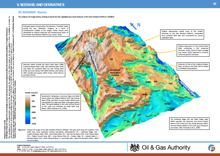
Frogtech’s regional studies provide an integrated geophysical and geological study of basement evolution and basin formation.
These studies provide an integrated interpretation of basement geology, tectonic evolution and basin development including the following range of deliverables:
Basement Topography: The SEEBASE™ depth to basement model provides depth and geometry of the top basement surface highlighting basin depocentres and basement highs
Basement Geology: Analysis and description of basement terranes, assessment of terrane boundaries (including limit of oceanic and transitional crust), and interpretation of basement composition.
Tectonostratigraphic History: Plate reconstructions and summary of key tectonic events; implications for basin development; interpretation of major basement faults, and fault event maps for key events.
Basement Controls on Basin Architecture: Interpreted basin outlines, location and depth based on the SEEBASE and structural model;
Depth to Moho: Geometry and depth of the Moho surface.
Maps of Sediment, Crustal and Basement Thickness, and Beta Factor: Derivative maps created using the SEEBASE® and Moho models.
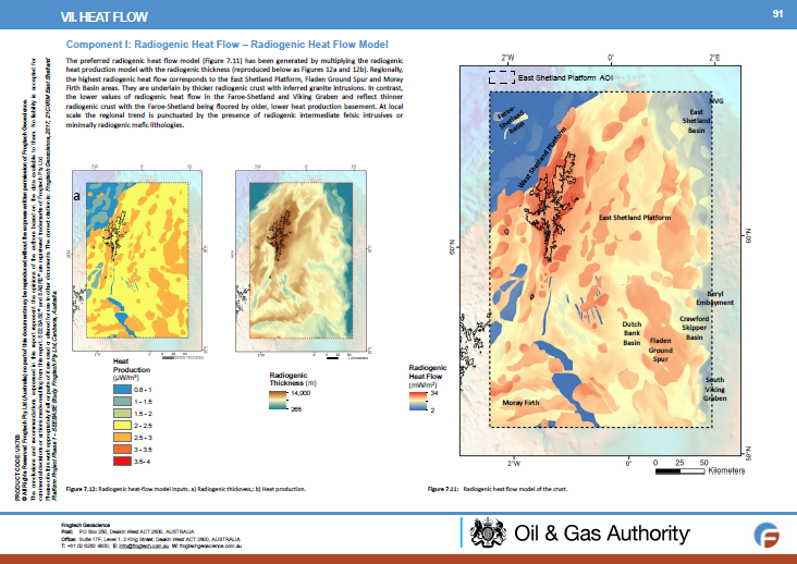
Inferred Basement Heat Flow: Computation of radiogenic heat production and heat flow, integrating basement geology and architecture, as well as timing and intensity of regional tectonothermal events.
Potential Field Datasets: advanced geophysical processing and enhancements.
All studies include an atlas-style, digital report, ArcGIS project, enhanced images and grid data. Available for immediate download.